Fujitsu's
New
Disaster-Management
System
for
JAXA
Goes
Live
1
April
2010
Fujitsu
announced
that
the
Sentinel
Asia
STEP-2
system,
which
it
built
under
the
auspices
of
the
Japan
Aerospace
Exploration
Agency
(JAXA),
became
fully
operational
on
March
31,
2010.
The
system
supports
disaster-prevention
activities
using
Earth
observation
satellites
operated
by
government
agencies
in
Asia,
including
JAXA,
to
acquire
satellite
imagery.
The
images
are
then
distributed
via
the
Internet
and
communications
satellites
to
countries
throughout
Asia,
including
those
that
do
not
own
satellites.
With
an
increasing
number
of
typhoons,
floods,
earthquakes,
tsunamis,
and
other
large-scale
natural
disasters
occurring
in
Asia
in
recent
years,
the
new
system
will
help
countries
to
quickly
respond
to
disasters.
During
a
trial
run
held
from
October
2009
through
March
2010,
the
system
was
used
to
track
the
volcanic
eruption
of
Mt.
Mayon
in
the
Philippines
on
December
25,
2009,
where
it
proved
capable
of
providing
useful
information.
To
support
the
transmission
of
information
to
countries
lacking
an
adequate
Internet
infrastructure,
Fujitsu
has
integrated
its
high-speed
file
transfer
solution,
BI.DAN-GUN,
to
the
Internet
and
satellite
delivery
functions
of
the
system,
increasing
the
speed
by
as
much
as
20-fold.
Overview
of
Sentinel
Asia
STEP-2
Sentinel
Asia
STEP-2
is
an
advancement
of
its
predecessor,
STEP-1,
and
has
been
newly
developed
to
deliver
information
to
disaster-response
organizations
from
countries
participating
in
the
Sentinel
Asia
project,
using
a
website
which
collects
and
displays
imagery
from
Earth
observation
satellites.
In
emergency
situations
such
as
natural
disasters,
the
STEP-2
system
will
provide
satellite
imagery
of
the
affected
region
when
requested
by
any
participating
country.
Fujitsu's
high-speed
file
transfer
service,
BI.DAN-GUN,
has
been
integrated
into
the
system's
Internet
and
satellite
data
transmission
functions,
increasing
the
effectiveness
of
transfers
between
distant
locations
or
over
poor
communications
lines.
It
also
supports
reliable
transmissions
of
satellite
imagery
to
areas
lacking
an
adequate
Internet
infrastructure.
As
high-efficiency
transfers
and
image
distribution
are
now
possible,
the
system
also
holds
the
promise
of
helping
other
countries
stay
abreast
of
natural
disaster
conditions
in
the
future.
The
system
started
trial
operations
in
October
2009,
and
went
into
regular
operations
as
of
April
2010.
Service
Application
of
Sentinel
Asia
STEP-2
1.
Regional
server
installation
(Thailand
and
Philippines)
To
make
the
Sentinel
Asia
system
more
accessible
to
the
countries
of
Southeast
Asia,
regional
servers
have
been
set
up
in
Thailand
and
the
Philippines
to
augment
the
central
server
in
Japan.
As a
result,
the
same
information
found
on
the
central
server
can
be
downloaded
or
viewed
from
any
of
the
regional
servers.
2.
Periodic
disaster
data
transmission
from
the
central
server
to
regional
servers
Information
such
as
forest-fire
data,
rainfall
distribution
images,
and
weather-satellite
images
are
transmitted
over
satellite
or
the
Internet
directly
from
the
central
server
to
regional
servers
at
five-minute
intervals(3).
Disaster-response
agencies
can
download
this
information
from
the
regional
servers
and
view
when
necessary.
3.
Emergency
information
distribution
during
disasters
(using
WINDS
satellite
communications
and
the
Internet)
In
times
of
disasters,
the
system
can
handle
emergency
requests
from
Asian
nations
to
provide
emergency
monitoring
of
affected
regions,
in
addition
to
periodic
transmissions.
Satellite
imagery
is
distributed
via
satellite
and
the
Internet
to
those
organizations
handling
emergency
monitoring
as
well
as
those
analyzing
satellite
images.
4.
Web-GIS
application
service
displays
satellite
images
overlaid
on
maps
The
Web-GIS
application
service
makes
satellite
images
of
disaster-affected
areas
easier
to
analyze
by
overlaying
them
with
maps,
topographic
lines,
and
other
geographic
information.
This
simplifies
on-screen
analysis
and
before/after
comparisons.
5.
Periodic
transmission
of
outside
data
information
on
forest
fires
and
rainfall
distribution
The
system
also
collects
data
from
Japan's
Meteorological
Agency,
the
University
of
Tokyo,
and
research
institutes
in
Australia,
Thailand,
and
Singapore,
providing
additional
information
on
forest
fires,
rainfall
distribution,
and
weather.
This
information
is
transmitted
at
regular
intervals
to
the
regional
servers
and
agencies
in
other
countries.
Hardware
Configuration
of
Sentinel
Asia
STEP-2
The
system
is
built
around
nine
Fujitsu
PRIMERGY
X86
servers,
with
Fujitsu
ETERNUS
NR1000
disk
arrays
for
storage,
and
Fujitsu
PRIMECLUSTER
high-reliability
platform
software.
Emergency
data
information
distribution
cases
during
trial
operation
period
October
4,
2009:
Flood
in
Philippines
October
6,
2009:
Flood
in
Nepal
November
2,
2009:
Flood
in
Vietnam
December
16,
2009:
Flood
in
Sri
Lanka
December
25,
2009:
Volcanic
eruption
in
Philippines
February
23,
2010:
Landslide
in
Indonesia
March
9,
2010:
Forest
fire
in
Bhutan
Future
Plans
for
Sentinel
Asia
During
2009,
a
total
of
58
organizations
in
23
countries,
including
Nepal,
Kyrgyzstan,
Fiji,
and
Taiwan,
along
with
nine
international
organizations,
participated
in
the
Sentinel
Asia
project.
It
has
also
entered
into
an
alliance
with
the
International
Charter
Space
and
Major
Disasters(4).
As
Sentinel
Asia
raises
its
international
profile,
it
is
expected
to
be
an
important
vehicle
for
Japan's
diplomatic
exchanges
in
the
field
of
science
and
technology
for
the
benefit
of
Asia.
Fujitsu
looks
forward
to
building
on
its
experience
with
system
development
for
aerospace
organizations
such
as
JAXA,
and
with
creating,
developing,
and
operating
social-infrastructure
systems
for
organizations
such
as
the
Japan
Meteorological
Agency
to
contribute
to
the
benefit
of
global
welfare
through
the
application
of
ICT.
Enlargement
of
SE
angle
on
Mt.
Mayon
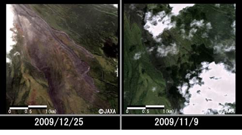
left: after lava flow (observation on Dec 15, 2009)
right: before lava flow (observation on Nov 9, 2009)
talk Satellite welcomes comment -
comment@talksatellite.com
|